


Le Poët-en-Percip Aulan Montagne de la Bohémienne

losjo
User
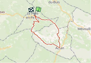

Length
13.7 km

Max alt
1133 m

Uphill gradient
488 m
Km-Effort
20 km

Min alt
764 m

Downhill gradient
504 m
Boucle
Yes
Creation date :
2025-05-11 16:14:16.561
Updated on :
2025-05-11 16:17:15.81
4h36
Difficulty : Medium

FREE GPS app for hiking
 SityTrail
IGN / Geographical institutes
SityTrail Plus
The world is yours!
About
Trail On foot of 13.7 km to be discovered at Auvergne-Rhône-Alpes, Drôme, Le Poët-en-Percip. This trail is proposed by losjo.
Positioning
Country:
France
Region :
Auvergne-Rhône-Alpes
Department/Province :
Drôme
Municipality :
Le Poët-en-Percip
Location:
Unknown
Start:(Dec)
Start:(UTM)
691185 ; 4902942 (31T) N.
Comments